THE DATA INFRASTRUCTURE
FOR PHYSICAL AI.
REscan captures large pedestrian and indoor spaces and turns them into labelled spatial data at 1000x speed for robots, world models, and autonomous system training.
Trusted & Partnered With


Who We Are
We Index the
Physical World.
Most AI exists in the cloud. Ours exists in the world. Spatial data is the missing layer of AI — REscan captures it, labels it, and makes it searchable at scale.
Capture
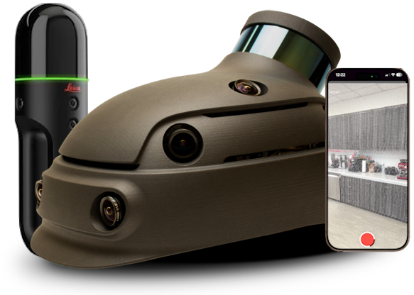
Our Gen 6 helmet-mounted scanner captures 250,000 sq.ft. per hour from a human-point-of-view — The exact format humanoid robots, AR headsets, and embodied AI agents need.
Understand
Our proprietary AI generates semantic data maps across every surface — enabling natural language search, automatic segmentation, and object classification without pre-trained models.
Act
Operators get a live, searchable digital twin of any environment — enabling decisions that were previously impossible without being on-site.
Solution
From Physical Space to Spatial Intelligence.
Collect and Reconstruct
Capture and Rebuild Reality
REscan's reconstruction pipeline transforms raw sensor data into fully processed digital twins — accurate point clouds, textured meshes, and semantically labeled environments, automatically.
- Egocentric Multi-Sensor Scanner — Reality Captured at Walking Speed
- Large-scale multimodal SLAM and neural reconstruction
- Mesh generation and texturing
AI Intelligence
Understand Every Object
REscan automatically maps semantic understanding onto every object, surface, and space in your environment — then makes it searchable in plain English. For custom object classes, label it once in 3D and the system produces thousands of training images and trains models that understand every new space they see.
- Ask anything — find any object, material, or space in seconds
- Automatic semantic labeling — no manual tagging required
- Rapid training data curation for AI and robotics pipelines
Platform
Search, Measure, Decide
REscan's web and mobile applications support exploring, querying, and analyzing spatial data. Measure distances, calculate volumes, annotate findings, and share secure reports from anywhere.
- Sub-centimeter line, volume, and area measurements
- Cross-section slicing and floor plan extraction
- Over a dozen other tools for site analysis and management